
Αρχείο:Struma-map.jpg

Μέγεθος αυτής της προεπισκόπησης: 774 × 600 εικονοστοιχεία . Άλλες αναλύσεις: 310 × 240 εικονοστοιχεία | 619 × 480 εικονοστοιχεία | 880 × 682 εικονοστοιχεία.
Εικόνα σε υψηλότερη ανάλυση (880 × 682 εικονοστοιχεία, μέγεθος αρχείου: 72 KB, τύπος MIME: image/jpeg)
|
|
Αυτό το αρχείο και η περιγραφή του προέρχονται από το Wikimedia Commons. Οι πληροφορίες από την σελίδα περιγραφής του εκεί εμφανίζονται παρακάτω. |

|
This map image could be re-created using vector graphics as an SVG file. This has several advantages; see Commons:Media for cleanup for more information. If an SVG form of this image is available, please upload it and afterwards replace this template with
{{vector version available|new image name}}.
It is recommended to name the SVG file “Struma-map.svg”—then the template Vector version available (or Vva) does not need the new image name parameter. |


Σύνοψη
| Περιγραφή |
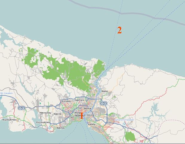
English: Map of the Bosphorus showing the location of the Struma in Istanbul harbor (1), and its eventual sinking point after it was towed out to the Black Sea (2). |
| Ημερομηνία | (UTC) |
| Πηγή | [1][2] |
| Δημιουργός | OpenStreetMap |
Αδειοδότηση
Το αρχείο διανέμεται υπό την άδεια Creative Commons Αναφορά προέλευσης-Παρόμοια διανομή 2.0 Γενική
- Είστε ελεύθερος:
- να μοιραστείτε – να αντιγράψετε, διανέμετε και να μεταδώσετε το έργο
- να διασκευάσετε – να τροποποιήσετε το έργο
- Υπό τις ακόλουθες προϋποθέσεις:
- αναφορά προέλευσης – Θα πρέπει να κάνετε κατάλληλη αναφορά, να παρέχετε σύνδεσμο για την άδεια και να επισημάνετε εάν έγιναν αλλαγές. Μπορείτε να το κάνετε με οποιοδήποτε αιτιολογήσιμο λόγο, χωρίς όμως να εννοείται με οποιονδήποτε τρόπο ότι εγκρίνουν εσάς ή τη χρήση του έργου από εσάς.
- παρόμοια διανομή – Εάν αλλάξετε, τροποποιήσετε ή δημιουργήσετε πάνω στο έργο αυτό, μπορείτε να διανείμετε αυτό που θα προκύψει μόνο υπό τους όρους της ίδιας ή συμβατής άδειας με το πρωτότυπο.
| Περιγραφή |
This map was created from OpenStreetMap project data, collected by the community. This map may be incomplete, and may contain errors. Don't rely solely on it for navigation. |
| Ημερομηνία | (see file history) |
| Πηγή | openstreetmap.org |
| Δημιουργός |
OpenStreetMap contributors |
| Άδεια (Επαναχρησιμοποίηση αυτού του αρχείου) |
OpenStreetMap data and maps are licensed under the Creative Commons Attribution-ShareAlike 2.0 license (CC-BY-SA 2.0). Το αρχείο διανέμεται υπό την άδεια Creative Commons Αναφορά προέλευσης-Παρόμοια διανομή 2.0 Γενική
|
| Georeferencing | If inappropriate please set warp_status = skip to hide. |
Καταγραφές ανεβασμάτων πρωτότυπου αρχείου
Transferred from en.wikipedia to Commons by DF5GO using CommonsHelper.
The original description page was here. All following user names refer to en.wikipedia.
- 2010-07-15 20:50 Crum375 880×682× (73237 bytes) {{Information |Description = Map of the [[Bosphorus]] showing the location of [[SS Struma|the Struma]] in Istanbul harbor, and its eventual sinking point after it was towed out to the [[Black Sea]]. |Source = [http://www.openstreetmap.org/][h
Ιστορικό αρχείου
Κλικάρετε σε μια ημερομηνία/ώρα για να δείτε το αρχείο όπως εμφανιζόταν εκείνη τη στιγμή.
| Ώρα/Ημερομ. | Μικρογραφία | Διαστάσεις | Χρήστης | Σχόλια | |
|---|---|---|---|---|---|
| τελευταία | 14:50, 24 Φεβρουαρίου 2012 | | 880 × 682 (72 KB) | DF5GO | {{Information |Description={{en|Map of the en:Bosphorus showing the location of the Struma in Istanbul harbor (1), and its eventual sinking point after it was towed out to the en:Black Sea (2).}} |Source=Transferred from [... |
Συνδέσεις αρχείου
Τα παρακάτω λήμματα συνδέουν σε αυτό το αρχείο:
Καθολική χρήση αρχείου
Τα ακόλουθα άλλα wiki χρησιμοποιούν αυτό το αρχείο:
- Χρήση σε de.wikipedia.org
- Χρήση σε en.wikipedia.org
- Χρήση σε he.wikipedia.org
- Χρήση σε nl.wikipedia.org
- Χρήση σε tr.wikipedia.org